

Good Systems Project Leverages Digital Twins to Make Austin Smarter
Imagine a city that can predict traffic jams before they happen, optimize energy use based on real-time weather data and even warn residents about how a nearby fire might spread. What once sounded futuristic is now on the horizon thanks in part to researchers from "A Good System for Smart Cities," one of the Good Systems grand challenge’s six core projects.
At the heart of this project is a powerful tool: the digital twin. Traditionally, city data has been fragmented and siloed, making it difficult to get a holistic view of how urban systems interact. "A Good System for Smart Cities" tackles that challenge by building an AI system that can link city datasets, extract valuable insights and identify potential biases. This information is then used to create digital twin models — virtual replicas of critical infrastructure, like transportation networks and water systems.
"Where there’s fire, there’s smoke"
Think of a digital twin as a sort of "city simulator." By feeding real-time data into these models, researchers can predict how different scenarios might play out. Say city council is proposing a new public transportation route. With a digital twin, decision-makers could virtually test its impact on traffic congestion, accessibility and ridership before ever breaking ground. This allows for more informed decision-making by ensuring new developments benefit the city and its residents.
There are myriad potential applications of digital twins in smart cities. The "Smart Cities" team has started out by focusing on fire and smoke mitigation and response in Austin, which stands out among major American metropolitan areas for its significant “wildland-urban interface” (WUI) — areas where human development and wildlands converge. This unique geography presents both opportunities and challenges, according to Nate Casebeer, a former geographic information system (GIS) analyst for the Austin Fire Department's (AFD) wildfire division and now a consultant for the City of Austin Office of Homeland Security and Emergency Management. "That's why we love Austin: because of our beautiful wildland areas and our beautiful forests," Casebeer said. "But when those intermixed with development, it kind of created an interesting fire dynamic in a lot of areas: there are traditional wildland firefighters and there are traditional urban firefighters, and those are two very different skillsets."
"One of the major impacts of fires that go unrecorded and undocumented are smoke impacts, which are one of the leading impacts from a wildfire to the population's health, and there isn't a lot out there dedicated specifically to tracking the impacts of the smoke."
— Nate Casebeer, Austin Office of Homeland Security and Emergency Management
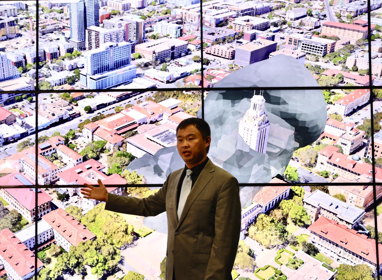
This unique challenge is at the heart of a digital-twin tool called "FireCOM," developed in collaboration with the AFD by Junfeng Jiao (pictured above), an associate professor in the School of Architecture, and his Texas Smart Cities team. This system combines real-time data on fires, buildings and weather to predict smoke dispersion and issue early warnings, particularly crucial in the complex WUI environment. "One of the major impacts of fires that go unrecorded and undocumented are smoke impacts," Casebeer said. "Smoke impacts are one of the leading impacts from a wildfire to the population's health, and there isn't a lot out there dedicated specifically to tracking the impacts of the smoke."
Justice Jones, AFD’s wildfire mitigation officer (and Casebeer’s former manager), emphasized the importance of focusing on smoke: "There's the old saying, 'Where there's smoke, there's fire.' But it's also true that where there's fire, there's lots of smoke." In other words, there’s a critical need for systems that can predict and manage not just the fire itself, but its far-reaching effects on air quality and public health, especially in areas where urban and wildland zones meet. "It's time for communities to recognize the full impact of wildfires," Jones added.
The digital twin technology aims to bridge this gap. "It's a two-way street," Jiao explained. "We collect the data from the physical world and run simulations in the digital world, but we also use the simulation results to optimize what we're controlling in the physical world. So, it's not just a monitoring system. It's a monitoring system, plus a control optimization system."
Three-part twins
Digital twin systems comprise three major components, according to Jiao:
- Sensors that transfer data from the physical world to the digital world
- Communication technology that allows data to be transmitted, simulations to be run, and IoT devices to be integrated
- Computational power needed to run simulations and prediction models
These components work together to create a dynamic, real-time representation of the city and its surrounding wildlands. Sensors throughout the urban and wildland environments collect data on factors such as wind speed, temperature and air quality. This information is then fed into the digital twin, where powerful algorithms simulate how a fire might spread or disperse under various conditions, considering the unique challenges of the WUI.
Casebeer explained the genesis of this approach. "The Austin Fire Department had a fire instances page, but it wasn't linked to a map and didn't get much traffic," he said. "So we said, 'How can we better communicate in real-time to the public?' And from there, we wanted to project out potential impacts. Which way is the wind blowing? Where are the vulnerable populations — the nursing homes, daycares, hospitals — and can we create a methodology to warn these populations ahead of time of potential impacts from smoke?"
By predicting the path of smoke dispersion across both urban and wildland areas, firefighters can make more informed decisions about evacuation routes and resource allocation. City officials can also issue targeted warnings to residents in areas likely to be affected, potentially saving lives and minimizing property damage.
The collaborative nature of the project has been key to its success and future potential. "We all contributed to working on the project and working with Good Systems to develop and improve on the project," Casebeer said. "And it's really exciting to see it has taken a life of its own and grown to potentially an all-hazards solution that we can continue to build upon as a digital twin framework."
This evolution from a fire-specific tool to a broader emergency management platform demonstrates the potential versatility of digital twins. Looking to the future, the team is exploring innovative ways to enhance the digital twin's capabilities. For example, Austin Energy just invested in a software solution that leverages cameras set up across Austin and Travis County that provide live feeds of fires, according to Casebeer. Then AI is used to identify smoke-producing impacts, "and we get notified and the fire department gets notified," Casebeer explained. "So we could theoretically integrate that, model them and start to validate those smoke-producing impacts and the projections that are built into the digital twin. That's something that we're looking at into the future."
This integration of AI-powered camera systems with the digital twin framework represents a significant leap forward in real-time monitoring and prediction capabilities. By validating smoke projections against actual observations, the system can continuously improve its accuracy and effectiveness, providing even more valuable information to emergency responders and city planners.
"We can do all these things with data and AI models, but none of them are going to be useful and usable unless we build the community and humans in them."
— Dev Niyogi, "A Good System for Smart Cities" project co-lead
Stay Human
"A Good System for Smart Cities" goes beyond the technological possibilities by emphasizing the importance of ethical considerations and community engagement. This human-centered approach is central to the Good Systems ethos, ensuring that technology serves the needs of the people, not the other way around. As project co-lead Dev Niyogi pointed out at the second annual Smart Cities and AI Innovations Symposium in May, "We can do all these things with data and AI models, but none of them are going to be useful and usable unless we build the community and humans in them."
As the share of the urban population continues to skyrocket — it is expected to reach 68% globally by 2050, up from 47% at the start of the century, according to the UN — the challenges of managing and sustaining cities grow increasingly complex. It’s through Research initiatives like Good Systems’ Smart Cities project, by harnessing the power of AI and digital twins, are laying the groundwork for smarter, more sustainable, more equitable cities.
"AI has the potential to touch almost every aspect of urban living, shaping the qualitative experience of life as well as the material benefit of smart urban planning," Heather Woofter, dean of the School of Architecture, said at the Smart Cities Symposium. "Therefore, it's ever more critical to democratize access and foster ethical engagement in AI."