

In the future, Texas is expected to face increasing exposure to a wide range of climate-driven natural disasters — most notably deadly catastrophic flooding from hurricanes, storm surges, and extreme rain events.
Making Texas more resilient in the wake of these disasters will require new and innovative ways of understanding the natural, technical, and social processes that underpin disaster preparedness and response.
Planet Texas 2050 has been working to accomplish this goal through a number of projects since its inception in 2017. The UT grand challenge brings together researchers from across disciplines to help solve some of the most pressing problems related to population growth and climate change in the state, including increasing natural disasters.
This year, the team is embarking upon six new flagship projects that will allow researchers to better address the most critical aspects of these challenges in a more focused way.
We — Patrick Bixler and Paola Passalacqua — are excited to work together on a flagship project known as Networks for Hazard Preparedness and Response. We’ll use integrated modeling to prepare for floods and other natural hazards by creating new maps and tools that will help scientists, first responders, and local, state, and federal agencies better understand extreme weather events and respond to them appropriately.
Disasters occur at the interface of many social, natural, and technical environments. Typically, researchers approach the modeling of hazardous events like floods, heat waves, and droughts through different disciplines working independently with their own technical approaches. However, increasing resilience in the face of multiple hazards will require a transdisciplinary effort that is both problem-focused and solutions-based, which is what this flagship hopes to accomplish. Our aim is to reduce loss of property and life from disasters and promote collective well-being by bringing together knowledge from multiple disciplines.
Building better flood maps
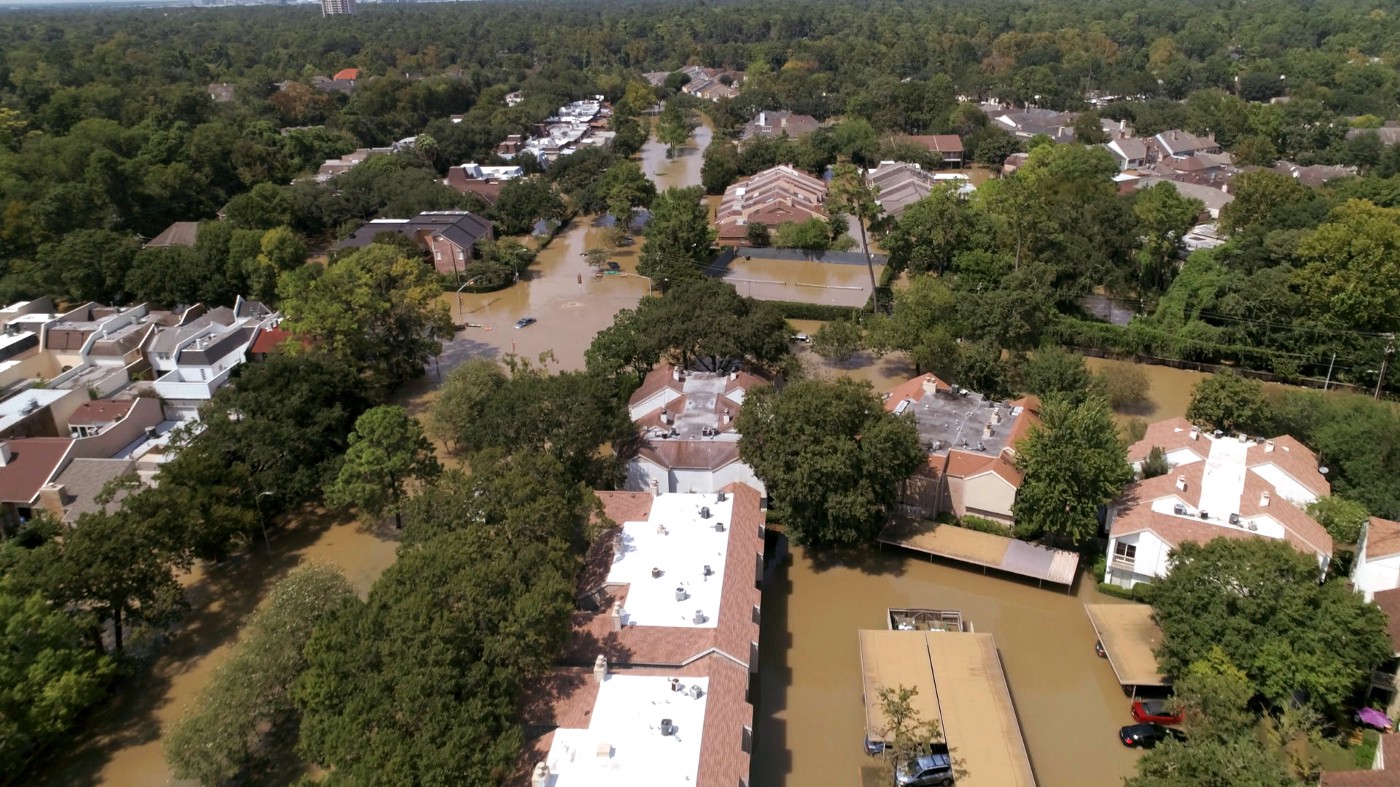
In Texas and beyond, the most deadly and costly natural disaster is flooding. Preparation and response are limited because flood and risk maps commonly available to local decision-makers and residents aren’t as accurate and informative as they could be.
Using LiDAR data that detects depressions in Texas’ topography, our team is working to create new flood maps that will provide a real-time assessment of potential flooding, including flooding from rivers and direct rainfall, that isn’t available today. We will combine these with maps with social vulnerability scores, which is another way of saying how at-risk a population is because of factors like age, income, language, family composition, and distance to the nearest hospital, among others. After all, part of building resilience is not only knowing where it will flood but also which populations will suffer the most because of that flooding, given any of these factors.
Ultimately, we plan to integrate all these layers into a giant framework that will allow us to study the interaction of flooding, transportation infrastructure, and — eventually — risk governance and emergency response networks that crisscross cities and the state to show what resources are available to particular areas.
Working closely with communities
As part of the study, we will work closely with two communities, in particular: the Dove Springs neighborhood in Southeast Austin and a 7-county region in Southeast Texas near Beaumont, both of which have seen significant flooding in recent years resulting in widespread devastation.
In Southeast Texas, we will work with the Southeast Texas Flood Coordination Study group, a network of state, local, and federal agencies and emergency response teams. In Southeast Austin, we’ll work with the City of Austin and the community group Go Austin!/Vamos! Austin to get feedback on our modeling and better inform our process. We also hope local agencies from both regions will be able to use our maps to make better decisions about disaster preparation and response.
Over time, this work will feed into an effort we are tentatively calling a “Texas Disaster Decision Theatre,” where academics and policy makers can come together to experience hazard simulations and work collaboratively to devise new policies and practices that will keep Texans safer. We plan to meet quarterly with a wide range of stakeholders to look at what our new maps and models are able to accomplish with flooding and see how those lessons can be applied to other hazards like wildfire and extreme heat.
As a state, Texas has the greatest exposure to the widest range of natural disasters, and we also sit in a place that is going to see the biggest impacts from climate change. In the future, the number and frequency of things like droughts and extreme rain events is only going to increase. That’s why it’s more important than ever to be prepared when disaster strikes. We hope our work will help accomplish that.
Read other stories in this series: Looking to the Past to Prepare for Our Future